LandSat "Earth as Art" images
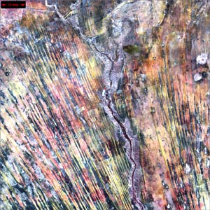
Kalahari Desert, Namibia, Africa
On the edge of the Kalahari Desert in Namibia, sand dunes are moving onto once-fertile lands in the north. Healthy vegetation appears red in this image. Look for the one red dot in the center of the image. It is the result of a center-pivot irrigation system. It looks as if at least one optimistic farmer is still working the fields despite the approaching sand.
This image was taken on 8/14/2000.
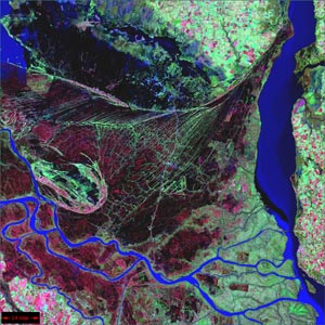
Parana River Delta, Argentina, South America
The Parana River delta is a huge forested marshland about 32 kilometers (20 miles) northeast of Buenos Aires, Argentina. The river and its many branches appear a bright blue. Healthy vegetation appears red and green. This image clearly shows the striking contrast between dense forests and wetland marshes, and the deep blue ribbon of the Parana River.
This image was taken on 5/26/2000.
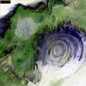
Richat Structure, Mauritania, Africa
The so-called Richat Structure is a geological formation in the Maur Adrar Desert in the African country of Mauritania. Although it look like an impact crater, the Richat Structure formed when a volcanic dome hardened and gradually eroded, exposing the onion-like layers of rock. In this image, vegetation appears green while the volcanic rock is various hues of purple.
This image was taken on 1/11/2001.

